Here
on the north eastern part of the Queen
Charlotte Islands lies the Naikoon Provincial Park encompassing
72,640 hectares of Graham Island. The Queen Charlotte Islands consist
of more than 150 islands, 50 to 130 kilometres west of British Columbia's
mainland. The islands are often referred to as "the Misty Islands" because
of the often overcast and foggy skies.
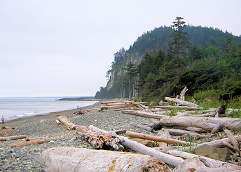
Most of
the parks forest cover
is made up of stunted lodgepole pine, red and yellow cedar that surround
the low boglands of the area. On the well drained higher regions grows
a lush forest of western hemlock and sitka spruce.
The wildlife
of the Naikoon Provincial Park area are a mix of introduced and native
species including the abundant black tail deer, racoons, red squirrels
and beavers as well as herds of wild cattle left over from the domestic
stocks of early settlements. Dolphins, porpoises, hair seals and California
Grey whales can be spotted in the off-shore waters. The birdlife is
abundant and similar to that of the nearby mainland. The rivers and
streams within the park are home to a wide variety of fish species.
The Tlell River has large runs of coho salmon and steelhead trout. There
are also cutthroat trout and Dolly Varden char in most of the streams.
The
native inhabitants of the Queen Charlotte Islands refer to the park
area as "Nai-kun", referring to Rose Spit, the point of land jutting
off of the northern part of the island, which was adapted to Naikoon
hence the name of the park. The Haida are the traditional residents
of the Haida Gwaii or "Misty Islands". They are noted for their proud,
bold, vigorous, and resourceful qualities as well as their fierce tribal
war practice, canoeing prowess and artistry. Explorer, Juan Perez is
credited as being the first European to visit the Queen Charlotte Islands.
LOCATION
The islands
are accessible by scheduled flights from Vancouver
and Prince Rupert and by BC Ferries
between Prince Rupert and Skigegate. Highway 16 which connects the island
communities also provides access to Tlell, Mayer Lake and Masset
which are the closest communities to the undeveloped interior of Naikoon
Provincial Park.
PARK
FACILITIES & ACTIVITIES
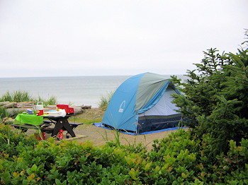
Camping
- Agate Beach Campground has 43 units and is located west of Tow Hill
and Misty Meadows Campground has 30 units. Toilets, water and firewood
are provided at both. There is wilderness camping permitted throughout
the park and three rustic shelters are provided near Cape Ball and Oceanda
Rivers and at Fife Point.
Fishing
and Boating - A car top boat launch is located at Mayer Lake. Anglers
may try their luck at Tlell River, Mayer Lake and other waterways within
the park.
Hiking
and Trails - An extensive trail system of varying difficulty and
length leads the visitor to the scenic features of Naikoon Provincial
Park.
COMMERCIAL
FACILITIES
Gas, accommodations
and other necessary supplies are found in Sandspit, Queen Charlotte
City, Tlell, Port Clements and Masset.
Information & Services
If you would like to have your business listed, please Click Here.

 Here
on the north eastern part of the
Here
on the north eastern part of the 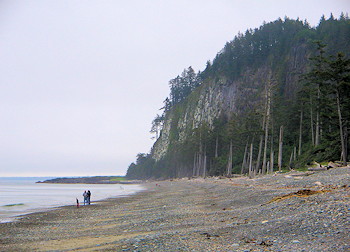 The
native inhabitants of the Queen Charlotte Islands refer to the park
area as "Nai-kun", referring to Rose Spit, the point of land jutting
off of the northern part of the island, which was adapted to Naikoon
hence the name of the park. The Haida are the traditional residents
of the Haida Gwaii or "Misty Islands". They are noted for their proud,
bold, vigorous, and resourceful qualities as well as their fierce tribal
war practice, canoeing prowess and artistry. Explorer, Juan Perez is
credited as being the first European to visit the Queen Charlotte Islands.
The
native inhabitants of the Queen Charlotte Islands refer to the park
area as "Nai-kun", referring to Rose Spit, the point of land jutting
off of the northern part of the island, which was adapted to Naikoon
hence the name of the park. The Haida are the traditional residents
of the Haida Gwaii or "Misty Islands". They are noted for their proud,
bold, vigorous, and resourceful qualities as well as their fierce tribal
war practice, canoeing prowess and artistry. Explorer, Juan Perez is
credited as being the first European to visit the Queen Charlotte Islands.
 PARK
FACILITIES & ACTIVITIES
PARK
FACILITIES & ACTIVITIES