|
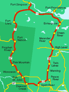 PEACE
LIARD TOUR PEACE
LIARD TOUR
6 - 9 days
This
unusual BC circle tour takes you through the heart
of the Northwest, and traces the path of some of the
West's most daring pioneers. Many of the towns along
the way were first established by fur traders in the
1700's and 1800's. Although most of the roads are
paved two-lane highways, this tour gives you a birds-
eye view of the challenges that were ahead of early
British Columbia inhabitants.
You
begin your trek in Dawson
Creek, "Mile 0" of the Alaska
Highway. You can reach Dawson
Creek by means of Highway 97, which
traces the gold rush route from Cache
Creek and Highway 1.
Visit
Dawson Creek's Information Centre and museum (housed
in an historic railway station), or Walter Wright
Pioneer Village for a glance at the town's past before
continuing north on Highway 97.
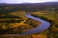 |
|
Peace
River Valley, near Ft. St. John.
Photo Courtesy of Northern BC Tourism
|
Fort
St. John (73 km/46 miles from Dawson
Creek) is the oldest former fur trading post in this
area, dating back to 1792. The Lookout on 100th Street
captures a breathtaking view of the Peace River.
Fort
Nelson (480 km/300 miles from Dawson
Creek) was established as a trading post in 1805.
29 km/18 miles northwest you will take to BC Highway
77 north (watch for the signs). Although the quality
of this gravel road can be variable during rainy weather,
it is traversable by RVs. Be aware of pot holes due
to rain.
The
Liard Highway is famous for its beauty. Cross Country
skiing, as well as canoeing, kyaking and wildlife
viewing are popular here. A trail leads you west to
Maxhamish Lake Provincial Park, situated less than
20 km/13 miles south of the BC/NWT border. There are
no federal or provincial campgrounds within the last
80 km/50 miles of the Liard Highway.
Fort
Liard (you are now on Highway 7) is the first town
you will come to as you cross into the Northwest Territories
and is known for its birchbark crafts. The Nahanni
National Park Reserve, a World Heritage Site is nearby.
Near
Fort Simpson (approximately 280 km/175 miles, just
north of the Highway 7 and Highway 1 interchange)
are several parks. The Kakisa Territorial Park and
Sambaa Deh Territorial Park offer camping, fishing,
and views of nearby waterfalls. Your route will then
continue on Highway 1 east.
Often
called "The Waterfalls Route" this highway
parallels several stunning waterfalls. Twin Falls
Gorge Territorial Park is outside of the community
of Enterprise (393 km/246 miles), where you can visit
Alexandra Falls and Louise Falls.
The
Northwest Territories' border with BC and Alberta
runs along the 60th parallel. The NWT Arctic Tourism
Information Centre at the border of Alberta offers
regional arts and craft displays, travel information
and coffee. The road changes to Highway 35 at the
border.
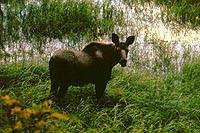 |
|
Cow
Moose
Photo Courtesy of Wayne Sawchuk
|
The
area of High Level, Alberta (191km/119 miles from
the border) offers some interesting historical tours.
Fort Vermilion, 80 km/50 miles east of Highway 35,
was established by fur traders in 1788. The community
of La Crete (just south of Fort Vermillion) was founded
by Mennonites at the turn the 20th century. An annual
Farmers' Day celebration in August includes traditional
Mennonite dishes.
The
area outside of the towns of Manning and Grimshaw
(280km/175 miles from High Level) is rich farming
country. Fishing opportunities abound at Notikewin
Provincial Park, just north of Manning.
Lac
Cardinal near Grimshaw hosts a pioneer village and
museum. From Grimshaw your drive turns southwest and
takes you along Highway 2 to Highway 49, which heads
directly west to Dawson Creek (184 km/115 miles. The
last leg of your journey back to BC is approximately
105 km/66 miles along a paved, secondary road.
Be
sure to browse the Points of Interest:
Read
a Travelog:
|