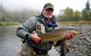
Northern Lights Lodge: A unique fly fishing lodge offering guided fly fishing on 4 wilderness rivers in the Cariboo Mountains. Wild native Rainbow Trout on the fly! more
Rocky Mountain Holidays: Rail Vacations in the Rocky Mountains & Western Canada! Rocky Mountain Holidays customize vacations that combine the romance of train travel with the magnificent scenery of Western Canada. more
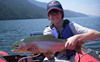
Escott Bay Resort: The adventure starts with fishing, hiking, horseback trail riding, pack trips and hunting – and with the snow comes x-country skiing & snowmobiling. Located between Tweedsmuir and Itcha Ilgachuz Par... more
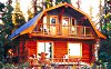
Elysia Resort: Our full service getaway destination on Quesnel Lake offers fishing for Rainbow Trout, romantic getaways, great dining, and vacation packages in lakeview rental cabins & guest rooms. You'll be warmly... more
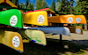
Bowron Lake Canoe Rentals: Rent all the boats and supplies you need to canoe or kayak the Bowron Lakes Canoe Circuit. We have over 130 canoes and kayaks, and 25 years experience. We also offer lodging and complete canoe trip pa... more