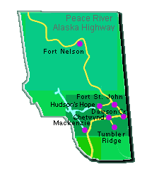
Chetwynd
| Dawson Creek | Fort
Nelson
Fort St. John |
Hudson's Hope | Mackenzie
Pouce Coupe | Taylor
| Tumbler Ridge
CHETWYND
This is a land of fertile valleys, great lakes and rivers,
jagged mountain ranges and snowcapped peaks. There are a number
of nearby lakes that can offer excellent fishing, boating and
camping. Visitors enjoy hiking, biking in the summer and skiing
& snowmobiling in the winter. Chetwynd is 310 km (192 mi.) north
of Prince George, on Highway 97, 102 km (63 mi.) west of Dawson
Creek, 65 km (40 mi.) south of Hudson's Hope and 95 km (59 mi.)
north of Tumbler Ridge.
DAWSON
CREEK
Mile "O" on the famous Alaska Highway. Camping,
fishing and hunting are all popular activities in the area as
is hiking, biking, wildlife viewing, skiing and snowmobiling.
The town itself contains an interesting mix of shops, museums
and galleries. Dawson Creek is 102 km ( 63 mi.) north of Chetwynd
on Highway 97 and 412 km (256 mi.) northeast of Prince George.
FORT
NELSON
Fort Nelson, named after Admiral Nelson, was established as
a fur trading post in 1805. The community came into more prominence
after the Alaska Highway was completed. Ribboned with thousands
of kikometres of rivers, dotted by hundreds of lakes and crowned
by the majestic Rocky Mountains, the area surrounding Fort Nelson
is an outdoor enthusiasts delight. Fort Nelson is 381 km (236
mi.) north of Fort St. John on Highway 97 (Alaska Highway) and
454 km (281 mi.) north of Dawson Creek.
FORT
ST. JOHN
The city of Fort St. John is the hub of the Northeast, serving
an area population of over 50,000. For the outdoor lover, the
areas around Fort St. John abound with endless opportunities for
hiking, camping, fishing, hunting, skiing and more. Fort St. John
is 75 km (47 mi.) north of Dason Creek on Highway 97 and 88 km
(55 mi.) east of Hudson's Hope on Highway 29.
HUDSON'S
HOPE
Hudson's Hope is situated midway between Chetwynd and Ft.
St. John along Highway 29. This route that follows the Peace River,
is the most scenic in the area. One unique feature in the area
is Williston Lake, one of the largest man made lakes, created
during the building of the W.A.C. Bennet Dam. Hudson's Hope is
64 km (40 mi.) north of Chetwynd on Highway 29mand 90 km (56 mi.)
west of Fort St.John on Highway 29.
MACKENZIE
The town of Mackenzie was named after the famous explorer
Alexander Mackenzie, who camped near the townsite on his epic
journey to the Pacific in 1793. Mackenzie, nestled between the
Omineca and Rocky Mountains, is know as the "Gateway to Williston
Lake" the largest manmade lake in Canada. Mackenzie is 190
km (118 mi.) north of Prince George on Highway 39.
POUCE
COUPE
Pouce Coupe is the oldest municipality in the Peace River,
it was incorporated in 1932, but the first European settler, Hector
Tremblay arrived here in 1898. More settlers came to this region
after 1911, when the Edson Trail (from Edson, Alberta) was cut
through some 400km (248mi) of wilderness. Pouce Coupe sits on
Hwy 2, 10km (6.2mi) from Dawson Creek and approximately 35km (22mi)
from the Alberta border
TAYLOR
Taylor, at Milepost 37, on the Alaska Hwy, sits on a plateau
overlooking the Peace River and valley, and starts as soon as
you cross the Peace River Bridge. The early settlers in this region
were trappers and farmers, but today Taylor relies on oil, gas,
lumber and pulp to keep the economy lively. Taylor on the Alaska
Hwy is only 60km(37mi) north of Dawson Creek, and 16km (10mi)
from Fort St. John. By road from Vancouver its 1221km (757mi)
and to Edmonton, Alberta its 647km (401mi).
TUMBLER
RIDGE
Tumbler Ridge is one of B.C.'s newest towns, it was incorporated
in 1981, and does not have the typical instant-town look, due
to good planning. This town was built to provide a home and community
to the employees and families who work at the two big mines. Tumbler
Ridge is located on Hwy 27S, (off Hwy 97) 105km (65mi) south of
Chetwynd. By road it's 1178km (730mi) to Vancouver, 120km (74mi)
to Dawson Creek
|