| The
Galloping Goose & Peninsula Trails |
Jan
Lee'sTravellin' News
All Photos Courtesy of CRD Parks

One of the longest trail systems on Vancouver
Island, the Galloping Goose and Peninsula Trails stretch from the
old mining town of Leechtown to Swartz Bay. Named after an historic
gas rail car that once ran between Victoria
and Sooke
in the 1920s, the Galloping Goose Trail makes up the first 60 km (38
miles) of the 100 km (63 mile) trail system. It is famous for both its
scenic vistas and accessibility to major urban areas and links more
than 7 regional, civic and provincial parks throughout the southwest
section of the island.
The Galloping Goose can be entered from 27 access points. Parking is
provided at specific locations and is easily accessible from main roads.
A good place to begin the trail by foot or bicycle, is Roche Cove Regional
Park, approximately 11 km/7 miles southeast of Sooke Potholes Provincial
Park. Parking and washroom facilities can be found at Gillespie Road.
Or you can pick up the trail from Rocky Point Road, approximately 10
km/ 6 miles southeast. There are parking facilities at this entrance
but no washrooms.
Trails within Roche Cove Regional Park offer horseback riding, hiking
and secluded walks. The 117 hectare park shares its east boundary with
Matheson
Lake Provincial Park. Bike riding is prohibited on the Matheson
Lake trails, which includes some steep embankments and heavily forested
areas. It is a good area for nature viewing and although it does not
have a boat ramp, kayaks and other smaller boats can be used on the
lake.
Heading southwest from these points takes you towards Sooke Potholes
Provincial Park, another day park that offers swimming and fishing.
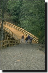
The trail follows the Sooke River over a couple of trestles that provide
easy transit for bikers in heavily forested areas. The trail eventually
ends at Leechtown, an abandoned mining town about 9 km/5.5 miles from
Sooke Potholes Provincial Park.
Roughly 9 km/5 miles north of the parking facilities at Roche Cove
Regional Park, is Devonian Regional Park. Gentle walking trails take
you through wooded terrain, along side a creek and Sherwood Pond. Devonian
Regional Park overlooks the Strait
of Juan de Fuca and provides a serene location for picnics or studying
marine wildlife. The Devonian walking trails are considered accessible
for individuals who are not able to hike steeper terrains, although
the trails are not wheelchair accessible.
A 3 km/1 mile jaunt south from the Galloping Goose trail at Happy Valley
Road takes you to Witty's Lagoon. The regional park is known both for
impressive archeological sites and for its pristine marine environment.
Once the home of the Northern Straits Salish people, Witty's Lagoon
has 5 known archeological sites. It is also an excellent area in which
to study wintering wildfowl, local marine life or the subtle flowers
of spring and summer foliage.
 From
this point on, access to the Galloping Goose and Peninsula trails becomes
easier. There are access points (some with parking facilities) approximately
every 2-8 km/1-5 miles along the route. (Click
here for a map of the trail). From
this point on, access to the Galloping Goose and Peninsula trails becomes
easier. There are access points (some with parking facilities) approximately
every 2-8 km/1-5 miles along the route. (Click
here for a map of the trail).
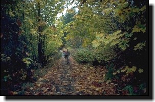
Most of the Galloping Goose trail is gravel or dirt surface, with moderate
to easy terrain. As the trail approaches the Esquimalt and Victoria
areas, you will encounter some paved sections and will find that the
bicycle and foot traffic increases. There is an arm of the trail that
juts south through the residential community of Esquimalt and is referred
to as the "Downtown Connector". The Selkirk Trestle provides scenic
vistas for casual strolling along the waterway. The connector is commonly
used by bicycling commuters travelling to downtown Victoria.
North of Victoria, the Peninsula Trail travels through Saanich, along
Cordova Bay and through Lochside Park. Take note that the trail detours
twice in this area, requiring travellers to cross over roads in order
to continue on the trail. The first location is at Blenkinsop Lake,
approximately 4 km/2.5 miles north of the downtown connector. Follow
the signs along Blenkinsop Road to the trail on the other side of the
lake. The other detour occurs at Island View and Pat Bay Highway, approximately
10 km/6 miles further. Turn left at the access point at Island View
and continue until you reach Pat Bay Highway, then follow it north to
Mt. Newton Cross, where the trail resumes.
There are some great places to investigate along this stretch of the
trail, including Mattick's Farm and the Saanich Historical Artifacts
Society. Elk/Beaver Lake Regional Park lies on the opposite side of
the Peninsula Trail from Mattick's Farm, and is accessible from Pat
Bay Highway. The park marks the home of another historic railway system,
the "Cordwood Limited", which stretched between Victoria and the small
community of Sidney. Even after the railway closed in 1919, the park
remained a favourite location for outings. Known as the "Freshwater
Playground of Victoria" in the 1930s, it once had a tea room, outdoor
dance hall and a chocolate factory to entertain local visitors. It is
now a protected regional park.
The last 14 km/9 miles of the Peninsula Trail is paved, and runs through
the communities of Central Saanich and North Saanich. The trail passes
the Anacortes ferry terminal, and the town of Sidney
to its conclusion at Swartz Bay, the main terminal for Vancouver-bound
ferries. Hugging the northeast coast of Vancouver Island, it offers
a picturesque view of the Strait of Juan de Fuca. McDonald Provincial
Park lies near the end of the trail and is equipped with 50 campsites
(6 are walk in). The park offers boating, fishing, swimming and a birds-eye
view of the surrounding islands beyond.
REFERENCES FOR FURTHER INFORMATION
Read:
"Inside out British Columbia: A Best Places Guide to the Outdoors"
by Jack Christie. Published jointly by Sasquatch Books and Raincoast
Books, 1998.
Or contact:
Capital Regional District Parks in Victoria, at 250-478-3344
� Copyright Jan Lee
Jan Lee jnlee@sfu.ca
Be sure to read other
articles by Jan Lee in the BC Adventure Network

|